Find Me on YouTube
Right HERE
posted by Ben @ 3:37 AM Perma-Link
2 comments
![]()
![]()

This is me and my friend Brian at Davios which is across Columbus Ave from his restaurant, Smith and Wollensky's in Boston, MA. We hit the lunch at the latter restaurant celebrating WINE WEEK. For $10 (plus a lunch obviously) we got to have (pretty much) unlimited glasses of on average $110-a-bottle wine! The best wine I've ever had.
Then we went across the street to Davios and had a few before we retired to Brians pad where we proceeded to drink an Irish Car Bomb each in celebration of the recent St. Patrick's Day. Brian then "layed down" for a while, while long-time friend Rose and myself hung out. All in all that was my spring break all packed into one day!

posted by Ben @ 1:47 PM Perma-Link
0 comments
![]()
![]()
This entry is being made with my mobile phone! I'm excited anyways.....
posted by Ben @ 9:40 PM Perma-Link
0 comments
![]()
![]()
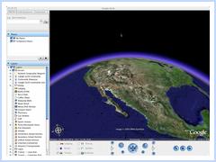 Wonderful news, especially because I recently got an iBook G4. Proud to announce too that Google Earth runs wonderfully on my 1.33ghz iBook G4 with 512mb ram (the bare bones iBook config).
posted by Ben @ 4:28 AM Perma-Link
0 comments
![]()
![]()
 What if you could access your bookmarks everywhere? Share them with others? What about seeing who has bookmarked the same things? Enter Del.icio.us (http://del.icio.us/), the social bookmarking site. Here you can search other peoples bookmarks by their title, or using TAGS ( as mentioned 2 posts back in the flick post ). My favorite thing to do is bookmark an interesting site, see who else has bookmarked it, and see what else they themselves have bookmarked.
posted by Ben @ 4:23 AM Perma-Link
0 comments
![]()
![]()
 Newly added is my flickr random photo badge from My Flickr Photostream. Flickr is a cool photosharing website that uses tags and
  Tag Clouds. Very interesting organzational tools and overall interconnected spider web-like interface/feel of the Flikr site. If you've never seen it check out Gadget Boy's Photos on flicker,
posted by Ben @ 1:23 AM Perma-Link
0 comments
![]()
![]()
posted by Ben @ 5:16 PM Perma-Link
1 comments
![]()
![]()
posted by Ben @ 1:40 AM Perma-Link
0 comments
![]()
![]()
 The Logitech® QuickCam Fusion raises the bar for webcams everywhere. It boasts 1.3 megapixels, a built in microphone that cancels echoes enabling headset-free video conferencing, and face tracking technology that allows you to control a 3d avatar with your facial expressions. $99 US, available now.
The alien's face is being controlled by the man at left.
While Webcams can be found for much cheaper (even from logitech) this camera may spark a new age in chat-rooms and videoconferencing, one in which you can become other people or things in a new way. Gives a new sense to the meaning of Avatar.
Quickcam Fusion Site Available now for $99 US plus shipping.
posted by Ben @ 1:28 AM Perma-Link
0 comments
![]()
![]()
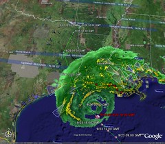
 Recently I saw NOVA - Battle Plan Under Fire on PBS. I like NOVA, I think they provide enough information to interest you, and explain things in a way everyone can understand. The show sparked me to make a post with some highlights and present a little information that I found after looking around on the net a little.
 The US military has bombs guided by GPS, UAVs remote controlled via satellite, oh yah and and a secret military internet that keeps everyone in communication. The war in Iraq is a laboratory for a new type of battlefield, where decisions can be made on the fly, and targets can be changed at the last minute. A highly advanced mapping system connected to the military internet keeps track of the locations of friendly units via GPS, and enemy units spotted by ground forces.
 The RQ-1 Predator (pictured at left) is a remote controlled drone that has cameras and sensors which send information and live video back across the military internet to the ones making the decision where bombs are dropped, and what shall be done next. Hellfire missiles can even be launched from the Predator. It's been in use since 1995 in Afghanistan, Bosnia, Kosovo, and Yemen according to the RQ-1 Predator Wikipedia article.
posted by Ben @ 12:58 AM Perma-Link
0 comments
![]()
![]()
 Imagine that your next motorcycle is a unicycle, powered by a hydrogen fuel cell! The EMBRIO is a concept transport vehichle from Canadian based Bombardier Recreational Products. It has...well i guess you could call it "landing gear" that deploy when speeds drop below 20kmph (12.4mph), althhough the unit's gyroscopes will balance the vehicle even while motionless. Steering is executed by shifting one's wait (leaning) rather than turning handlebars or a steering wheel. I know I want to be the first guy on my block to have one of these. Unfortunately fuel cells have a few hurdles that need to be overcome before everyone and they're brother will be driving cars powered by the technology. Which brings us to the next section...
 This new technology will also fight pollution and waste problems on a grand scale. The fuel cell car's only byproduct is water vapor (compared to harmful carbon monixide and much more) and in the micro fuel cell world, batteries are bad for our environment to dispose of improperly (which I'm sure most are). Hopefully the obstacles preventing us from launching large scale fuel cells in the transportation industry will be overcome, saving the earth, our collective conscience, and some money if we're lucky.
posted by Ben @ 5:24 PM Perma-Link
0 comments
![]()
![]()
 Cambridge SoundWorks PlayDock MP3
 This next guy is one I can personally vouch for because I own one. It'll just about fit into a nice large cargo pocket, and you can put your mp3 player in another pocket and music will just follow you around. It's great and loud for both the price ($95 at BestBuy.com) and its size. The OnTour takes 4 AAA batteries which last at least a few hours. AC adapter included.
posted by Ben @ 2:54 PM Perma-Link
1 comments
![]()
![]()

posted by Ben @ 5:44 PM Perma-Link
1 comments
![]()
![]()
 A japanese scientist and professor named Ishiguru, has designed what is probably the most beleivable android in history, affectionately named "Repliee Q1". He claims that his robot can fool you for a few minutes, that is, into beleiving that she is real. Although it can only sit in one place, and is not self contained, this is another step towards real waking and talking beleivable andriods.
posted by Ben @ 5:31 PM Perma-Link
0 comments
![]()
![]()
posted by Ben @ 4:41 PM Perma-Link
0 comments
![]()
![]()

posted by Ben @ 1:00 AM Perma-Link
0 comments
![]()
![]()

posted by Ben @ 9:51 PM Perma-Link
0 comments
![]()
![]()


posted by Ben @ 6:35 PM Perma-Link
0 comments
![]()
![]()
A "Techy's" take on the latest and greatest of new technologies and information services.


![]()


