Hurricane Rita Real-Time
Found a really cool Hurricane Tracking KMZ file for Google Earth. Gives windspeed, projected course, and spectral satellite imagery for hurricanes found worldwide.In conjucntion with the awesome real-time weather tools (scroll to the bottom to find the radar and satellite mosaics for the US) found over at googleearthhacks.com. I really feel like a weatherman with these amazing tools at my disposal.
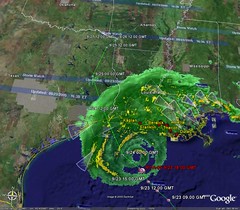
Here is an image of Hurricane Rita at 5:00 pm on Friday September 23rd:
Google Earth BBS Post: "Hurricanes live positions (v 1.0) worldwide data"
And of course the direct link to theKMZ Download
If you still haven't seen Google Earth then download it now
posted by Ben @ 5:16 PM Perma-Link
![]()
![]()


1 Comments:
Hi neighbor, found you via http://www.eng.uwaterloo.ca/~kkalu/gfeedmap/browse.php
gfeed - a blog neighborhood locator. Love the hurricane tracking tool!
Post a Comment
<< Home